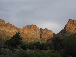
The road is ever calling! We're on our way to Zion National Park for two or three nights. We'll decide how many once we get there and see if we can get a campsite in the park! All of the information says the campsites (first-come, first-served) fill up pretty quick-by early afternoon. We couldn't get a reservation at one of the few you can reserve - so here we go!
Warning!--this is a long post, but I think you'll enjoy the moments we had here!
The quickest way to get from Bryce to Zion is down US89 to UT9 and across, but we won't be going that way.
And here's why! The last 15 miles or so on UT9 is nothing but switchbacks and up and down steep grades. Then you have a mile-long tunnel that won't accommodate any vehicle that's pulling another or taller than 13'1" - and we're 13'4" tall-and pulling! So, around we go.

Here's our route! There were a few that were shorter, but lots of mountain driving, so we decided to bypass those as well. There was one advantage to taking the longer route that took us through Cedar City....

It provided for a refreshment break compliments of our Rock Bridge family! (Sorry about that cup, Lizzie!)

Annie would loved some but it's not on her diet. This is her souvenir from Bryce Canyon- Rosie the Raccoon! She's such a Diva!
Well, we didn't make it in time to get a campsite in the park the first night. The ranger said they were full by 9AM! So our first night was in a commercial campground. A tight fit, too! So, the next morning I was up and at South Campground at 7:30 looking for available spaces! It's a good thing I did it. It was crazy! people dashing about trying to figure out who was leaving and registering for their spaces.
We got a fantastic space so we went ahead and paid for two nights in the park. So, then it's back to the other campground, get everything put away and head into the park - and this is what we get into! A mile-long backup of vehicles waiting to get through the entrance gate. Fortunately, they're not all going to the park. UT9 runs through the park and some of them are going through.
We got a great site for the two nights!


 |

| Most people camp here in a tent - it's a safe bet we were the biggest thing in the campground! |


After we got set up, the girls and I hoped on a shuttle bus to go "Up Canyon".
 |
Emi wrinkles her nose and said, "Oh, that really stinks!"
I replied, "That's just the fumes from the LP gas they use to run the buses."
"Well, no wonder it stinks! How do they get all that Elk pee gas?"
 |
| ALWAYS AN ADVENTURE WITH THESE THREE |

 |
| The girls with Abraham - Issac - Jacob at the Court of the Patriarchs |


This huge Cottonwood is in the front yard of the Zion Lodge.
We ended up at the top of the canyon at the Temple of Sinawava and the Riverside Walk trail.


The farther you go, the higher the walls go, and the narrower the canyon gets.
We finally reached the end of the trail on the riverside walk. The trail ends at the area where the "Narrows" begins.
The Narrows is the narrowest section of Zion Canyon. This gorge, with walls a thousand feet tall and the river sometimes just twenty to thirty feet wide, is one of the most popular areas in Zion National Park. The only way to see The Narrows by hiking along the paved, wheelchair accessible Riverside Walk for one mile from the Temple of Sinawava.
If you wish to see more, you will be walking in the Virgin River. This can involve wading upstream for just a few minutes or it can be an all day hike. You must get your feet wet since there is no trail. Most people choose to start their hike from the Temple of Sinawava via the Riverside Walk and then walk upstream before turning around and hiking back down to the Temple of Sinawava.
Most people hike The Narrows in the late spring and summer when the water tends to be at its warmest and the water level drops. However, this is also the time of year that storms can cause life-threatening flash floods. Water level fluctuates greatly from year to year and day to day depending on many factors such as rainfall and snow melt. When the river is running below 70 cubic feet per second (CFS), walking is moderately difficult, with knee deep crossings on the slippery and uneven river bottom with frequent pools up to waist deep.
When the current goes above 70 CFS, walking against the current becomes challenging and crossings of mid-thigh deep are frequent with pools that can be chest deep. If the flow goes to over 150 CFS, The Narrows will be closed to all travel. The Narrows also closes when a Flash Flood Warning is issued by the National Weather Service, and remains closed for two hours after the warning is lifted.


"Be careful!" I said.
"Oh, Poppy," said Emi, "I'm not going to fall - I'm the careful one."
Guess who fell?
A bird is nesting in that circle. There were lots of gold and purple finches.
Abi found a way to leave our prints behind without damaging the park!
Abi
Emi
Lizzie
So then we rode the bus all the way back down the canyon (about 40 minutes) to tell Noni all about our adventures.
But first Abi and Emi had to get their Junior Ranger Badges!
This is just the start of the ascent up the Wiggles.
Walter's Wiggles
We didn't make it all the way up, but here's what it looks like from up there.
Emi's Wiggle dance!
After we got back and the others were up, Friday was a fun day that included playing in the Virgin River!
Emi's many faces!
There's always maintenance and repairs on these long trips. Today's task is to re-string this day-night shade while Donna takes the girls to play in the river.
I wonder if it's too late to swap with her?
We're adding states to our camping map!
Utah!
Arizona!
Lizzie finished the requirements for her Junior Ranger badge!
The we all went "Up Canyon"
They made me wade in that COLD water!

down river
up river
We stopped at the Lodge for an ice cream, and then back to the campground to get things ready for moving on.


Tomorrow we head out for Vegas and California. But, we won't soon forget this place - and we will be back!


No comments:
Post a Comment